infos-pistes
 meteo
meteo webcams
From Alpe d’Huez to Col de Sarenne – Hiking
Contacts
38750 Alpe d'Huez
View map
e-mail : info@alpedhuez.com
Website : https://www.alpedhuez.com
Facebook page : https://www.facebook.com/alpe.huez
Openings
From 01/06 to 31/10 daily.Description
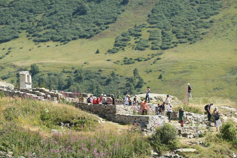
This walk takes you past the archaeological site of Brandes, an ancient mining village where silver was mined in the 12th century. A mountain pasture area, you'll also come across numerous flocks of sheep.
Once at the Col de Sarenne, you'll enjoy exceptional views of the Emparis plateau, La Meije and its glaciers.
This itinerary mainly follows the Col de Sarenne asphalt road (easily accessible by bike, baby carriage...).
TECHNICAL INFORMATION
Departure: Alpe d'Huez (Altiport)
Difference in altitude: 140 m
Round trip time: 4 h
Distance : 7 km
MAP AND TOPO :
IGN TOP 25 map no. 3335 ET - Bourg d'Oisans, Alpe d'Huez
OBP map no. 2 (Oisans au Bout des Pieds): trail no. 267
TO SEE ALONG THE WAY:
- The Brandes mines
- Herpie coal mines
- Herds at Col de Sarenne
THINGS TO SEE NEARBY :
- In Alpe d'Huez :
The Musée d'Huez et de l'Oisans and the Church of Notre Dame des Neiges (its architecture, its original organ in the shape of a hand stretched towards heaven and its 13 stained glass windows illustrating scenes from the Gospel)
- In Bourg d'Oisans :
Musée des Minéraux et de la Faune des Alpes (Museum of Alpine Minerals and Fauna), featuring France's first collection of Alpine minerals.
Services on site
- Pets welcome
- Not accessible in a wheelchair
Further information
Location
Start from the altiportDescription
This walk takes you past the archaeological site of Brandes, an ancient mining village where silver was mined in the 12th century. A mountain pasture area, you'll also come across numerous flocks of sheep.
Once at the Col de Sarenne, you'll enjoy exceptional views of the Emparis plateau, La Meije and its glaciers.
This itinerary mainly follows the Col de Sarenne asphalt road (easily accessible by bike, baby carriage...).
TECHNICAL INFORMATION
Departure: Alpe d'Huez (Altiport)
Difference in altitude: 140 m
Round trip time: 4 h
Distance : 7 km
MAP AND TOPO :
IGN TOP 25 map no. 3335 ET - Bourg d'Oisans, Alpe d'Huez
OBP map no. 2 (Oisans au Bout des Pieds): trail no. 267
TO SEE ALONG THE WAY:
- The Brandes mines
- Herpie coal mines
- Herds at Col de Sarenne
THINGS TO SEE NEARBY :
- In Alpe d'Huez :
The Musée d'Huez et de l'Oisans and the Church of Notre Dame des Neiges (its architecture, its original organ in the shape of a hand stretched towards heaven and its 13 stained glass windows illustrating scenes from the Gospel)
- In Bourg d'Oisans :
Musée des Minéraux et de la Faune des Alpes (Museum of Alpine Minerals and Fauna), featuring France's first collection of Alpine minerals.

 infos-pistes
 meteo
meteo webcams